One of the most meaningful gifts I got during graduation was a set of five basic land cards laminated and turned into bookmarks from a friend who introduced me to the game Magic: The Gathering. An attached note said: “I want to show you the world, but I have no money. Hope these inspire you to explore the world on your own.” Well, they have.
Here’s my version of the five basic lands – plains, island, swamp, mountain and forest – representing five places in the Philippines I’ve been to since then. 🙂
Plains: La Paz Sand Dunes, Ilocos Norte
The La Paz Sand Dunes is a protected sandy coastal desert and beach close to Laoag City, the capital of the province of Ilocos Norte. The sand dunes of Ilocos were said to be created by the interaction of the wind, sea, and river that together cause erosion and deposition. Everyone had a blast trying out the sand boarding and riding 4×4 vehicles around the dunes earlier this year during the Lakbay Norte Media tour.
Island: El Nido, Palawan
El Nido has the best, most beautiful islands and beaches I’ve seen in the country so far. Art and I only got to spend a few days in El Nido last year and we look forward to staying much longer (or perhaps retiring there someday). El Nido is located in the northernmost tip of mainland Palawan, bordered by the Linapacan Strait in the North, the Sulu Sea in the east, and the South China Sea in the west. El Nido has over 45 islands and islets, each with its own unique geological formations.
Swamp: Olango Island, Cebu
The group of islands found in the Central Visayas region is known for its wildlife sanctuary. Its terrain is marked by an extensive sandy beach, rocky shoreline, inshore flats, seagrass beds, coral reefs, mangrove forest, mudflats, and salt marsh grass. I got to go birdwatching in Olango Island in Cebu during a media workshop on reporting on bird flu a couple of years ago.
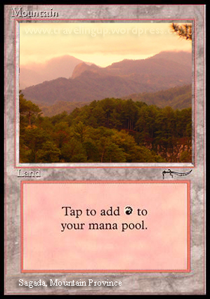
Mountain: Sagada, Mountain Province
Roughly 275 km North of Manila, Sagada is nestled in a valley at the upper end of the Malitep tributary of the Chico River some one and a half kilometers above sea level in the central Cordillera. The mountain village is known for having hanging coffins and limestone cliffs. Though memories of the cool climate, long hike to the Big Falls and caving in ice-cold water are still fresh in my mind, it’s been a few years since I’ve been to Sagada. This is another place I would love to visit again soon.
Forest: Tanay, Rizal
The serene Batlag Waterfalls, surrounded by a dense forest in Tanay, Rizal is a favorite getaway for weekend motorcycle rides and was one of the settings for our pre-nup shoot. With its lush trees and clear waters, the setting seems almost mystical. The area where Daranak Falls is also located, is bordered by the Sierra Madre mountain range. Tanay is roughly 57 km east of Manila.

NOTE: I got the idea for this from the article 7 Magic Cards Based on Mortal Kombat Characters from Dorkly.com. Original images were Photoshopped into basic Magic land cards. Magic: The Gathering is a copyright of Wizards of the Coast.


nice! i like how you coordinate Philippine landscape to Magic cards! astig. Reminds me of my high school days. My cards are mostly Water element
Nice one. Reminds me to visit Sagada soon. And El Nido too. 🙂
Thanks Supertikoy 🙂 I had a mostly red/green deck with lots of slivers 🙂 Loved the artwork esp. of Quinton Hoover.
Thanks Lili. Definitely two places worth going back to again and again.
Love it! Really unique and as a geek totally dig it.
Thanks Grace! 🙂
Oh this is so cool! My friends were so into Magic when we were in uhm, college. I never learned how to play so I can’t understand what it’s about, but this is just one creative post!
Cool! Puwede!
Thanks Gaye! By the way, I think “Wanderwoman” would look really cool on a t-shirt :p
Thanks Ding! 🙂
I would dig a M:TG set based on real life. These are cool.
Thanks Dandi 😀 Hopefully, I can add Snow-Covered mountains and other nonbasic lands in the future :p Hehe.